


Remarks on the Country lying between the Rivers St. Maurice and Saguenay, on the North Shore of the St. Lawrence
By Lennox Ingall
[Originally published by the Literary and Historical Society of Quebec in Transactions, Original Series, Volume 2 (1831)]
IT was not until a very recent period that the extensive tract of country comprised between the River St. Lawrence and the mountain ridge forming the land's height, towards the north and north-west, became at all known, either with respect to its natural history, or its capabilities for settlement; nor have the public at large, to the present day, been made acquainted with the results of the various examinations of this portion of the lower province.
Many of the surveyors who have been employed, were engaged by private individuals; and the reports of those sent out by the government, were of necessity confined to the circulation of a few copies for the information of the Legislature; and, with the exception of that excellent paper on the "Geognosy of the Saguenay Country," by Lieut. Baddeley, published in this society's first volume, I know of no other authentic account of the country in question.
I have already had the honor of laying before the society my observations on the country contained between the rivers St. Maurice and Aux Lievres, as far as the junction of that river with the Ottawa. I shall therefore confine myself in this paper to that interesting portion contained between the St. Maurice and Saguenay.
Having in my possession several private journals of surveys, as well as the maps and reports of the few public expeditions which have traversed this section of the country, I hasten to lay before the society my gleanings from the works above alluded to, trusting the few observations I have made may be the means of eliciting still further information on a subject that must be of the deepest interest to every well wisher of Lower Canada.
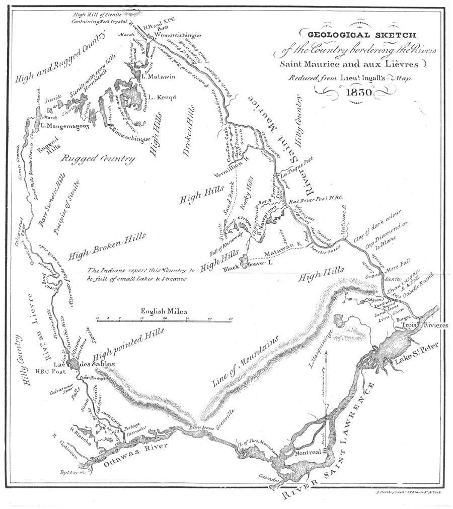
The accompanying map I compiled from plans of actual surveys, as well as various Indian documents, and I trust it will be found sufficient to answer the purposes of this paper.
Tradition states that as long since as the time of the Jesuits, the country between lake St. John and Quebec contained foot-paths frequently used by the early French settlers, but it this be correct, the minds of these men were so intent on the fur trade, then in its prime, that they cared or knew little about the agricultural resources of the country through which they travelled. Geological science at that period was so far behind the present day, that little on that head could be hoped for from the few Europeans then thinly scattered along the shores of this noble river.
At length the attention of the Provincial Government was called to this important subject, by the circumstance of the amazing influx of intelligent, enterprising emigrants, who annually arrived at Quebec, and almost invariably bent their steps either to the United States or the upper province.
Fully aware of the superior healthiness of the Lower province over the generality of the cultivatable lands in Upper Canada, the Legislature determined upon ascertaining whether a sufficient quantity of land fit for forming settlements, and of a quality equal to that in the upper province, did not exist in rear of the old French seigniorial grants, and extending from their line, to the foot of the mountains; and also, whether there was not a level tract of cultivatable land within that range of mountains.
Accordingly several sums of money were placed at the disposal of His Excellency the Governor in Chief, who nominated Commissioners for carrying the wishes of the House of Assembly on this subject, into effect.
In the years 1828 and 1829 expeditions were fitted out to explore — first in 1828, the country comprised between the rivers St. Maurice and Saguenay; and in 1829 to ascend the St. Maurice to its supposed source and examine the large tract of country lying between it and the Aux Lièvres descending that river into the Ottawa.
Besides these two expeditions others were fitted out on a smaller scale to explore the country lying between the St. Lawrence and the line marked out to be pursued by the two principal parties. Having, as above stated, laid my remarks before the society, on the Montreal district — I shall proceed with a description of the district of Quebec.
The lands situated within the seigniories lying on the shores of the St. Lawrence, from the river St. Maurice to the city of Quebec are alluvial deposits of good soil, similar to that existing on the shores of the Ottawa and in the neighborhood of Montreal: — with the exception of that great sand formation at the mouth of the St. Maurice. This silecious sand deposit extends a few leagues to the north-east and spreads a few miles into the interior, when the land is again observed to improve until it meets the ridge of high hills running from near the Grand Pille rapids towards the river Batiscan.
A great proportion of good land has been discovered to exist in the valleys of the Batiscan and St. Anne extending as far as the river Jacques Cartier, capable of supporting a large population. This tract contains but few swamps and is well watered with numerous lakes and rivers. — These rivers, after leaving their native mountain heights, increase in size and flow through a country well covered with hard-wood; but the land in the immediate neighborhood of the hills is encumbered with the bowlder-stones so common in most parts of Lower Canada.
In following the course of these rivers to the lakes from which they derive their source, a wild and rocky country is entered, abounding in steep precipices and ranges of high hills covered with a light sand. The hollows between these hills almost invariably contain lakes, formed by the expansion of the rivers passing through them; the timber growing around their shores, as well as on the sides of the hills, consists of birch, poplar, and balsam, with occasionally some pine, and a slight mixture of maple. The small rivers and streams, tributary to the Batiscan and Jacques Cartier, are full of heavy rapids, and these rivers, for a considerable distance into the interior, have occasionally small strips of what is termed interval land, reaching from the shores to the foot of the mountains, but decreasing in quality and growth of timber as they recede from the valley of the St. Lawrence. Around many of the lakes not far within the mountain ridge a sprinkling of hard-wood, such as young beech, black birch, elm, and black ash, are now and then discovered among the young growth of timber; but these spots of good land are of such small extent, as to be, at the present day, of little or no value.
It may not be amiss to observe that the Jacques Cartier river derives its source from a series of small lakes in the immediate vicinity of those which pour their waters into the Saguenay and Lake St. John. These lakes are represented by the Indians (and it is only from them we can at present obtain any information on the subject) as being situated among a series of barren mountains, thinly covered with a light sand, bearing birch and poplar; but as these mountains are not far from the rich valley of St. John, we must be cautious of placing implicit confidence in what they say, particularly as their contempt of all agricultural pursuits is proverbial.
On looking at the range of mountains seen from Cape Diamond, they are observed to stretch in an irregular circle from Cape Tourmente below the Island of Orleans, sweeping round towards the River St. Lawrence, several leagues above Quebec. On the south side of the river they again make their appearance in a semicircular form, at the distance of forty or fifty miles, but gradually approaching until they terminate on the shores of the St. Lawrence nearly opposite Cape Tourmente, enclosing within their vast circumference an alluvial deposit, which may justly be classed with the richest soils in America. The land in this tract (which we may term the valley of Quebec) is observed to rise gradually from the St. Lawrence to the foot of the mountains on either side of the river, and is well watered by numerous small rivers. In this paper I must strictly confine myself to the North Shore, although the south side of the St. Lawrence would be found equally interesting to the agriculturist or geologist.
From the middle of this valley rises Cape Diamond, a rocky hill of clay slate, lying in distinct strata, the interstices filled with calcareous spar, and containing small portions of rock crystal, from whence the Cape takes its name.
It is a favourite opinion that a portion of the waters of the St. Lawrence formerly flowed through the small valley of Cap Rouge, and rejoined its parent stream through the valley of the River Charles, thus forming an island of what now constitutes a cape of the main land. It would require no very great stretch of fancy to call to mind the period when the whole of the valley of Quebec was submerged as far as the foot of the circular range of mountains, forming a vast lake, whose waters seem to have retired gradually, without leaving behind any of those tremendous marks of violence, which appear to have been the result of the rushing of the waters from the mountain heights.
We may very fairly come to the conclusion that these extensive basins retained the waters in a quiescent state for many ages subsequent to the first convulsion, gradually depositing the carbonate of lime, which was held in solution, and which enclosed in the operation, the numerous marine animals now found embedded in the limestone formation, such as are found in the lime rock of Montmorenci; — this must have been previous to the last great catastrophe, as we find bowlder-stones of an enormous size lying on the surface of the secondary formation. It is worth mentioning that many of the lakes in the interior are gradually decreasing, but in no instance has any depost, but of sand, been the result.
The rocks, in situ, found in the section now under notice, are grey-wacke, clay-slate, and limestone; but this part of the subject has been so ably handled by Mr. Baddeley, that nothing more need or can be said on that interesting branch of science. I will merely, in quitting this digression, state that bowlders of considerable size are found scattered over the summit of the cape; these stones are of sienite, sienitic gniess, and a beautiful black sienite, (hornblende in excess) containing minute crystals of manganesian garnet. Not any of these rocks are found, in situ, nearer than the range of mountains situated to the north of Quebec.
The soil in the immediate neighborhood of the cape, forms a thin layer over the surface of the rock; in the valleys is marshey and cold, improving as the land rises towards the foot of the mountains, and again falling off, until it becomes more or less sandy and encumbered with rocks.
The mountains which recede far back in the rear of Lorette, an Indian village to the north-west of Quebec, contain a continuation of good land as far as the forks of the river Jacques Cartier, in the township of Stoneham, and extending into part of Tewksbury. This rich country is generally known by the name of "Val Cartier."
As the township of Stoneham is ascended towards the river St. Annes, in a W. N. W. direction, it becomes more hilly, and the soil consists of light sand much covered with stones. In this direction spots of land are occasionally seen on the shores of the small lakes and streams, which might be cultivated; but they occur detached and of small extent.
A singular rock existing in this part of the country was described to me by my friend Mr. Adams, an accurate observer of the beauties, of nature. He described it as exhibiting a front of clear rock, about sixty or seventy feet in width, glittering in the sun with a brilliant whiteness which rivalled the purity of crystalline marble, and conspicuous, towering above the adjacent hills, for a considerable distance. On approaching its base, Mr. Adams discovered it to consist of pure white quartz and felspar, the latter somewhat in a state of decomposition; it had all the appearance of having formerly been the bed of a cascade, in which case the waters must have fallen from a height of at least five hundred feet into the valley below, where are now situated three lakes, St. Thomas, St. Vincent, and William. Indeed the shores of many of the numerous lakes and rivers in this part of the country, are composed of rocky precipices or bluff head-lands, giving to the scenery a degree of wildness peculiarly characteristic of the mountain regions of Canada. Nor are these stupendous precipices confined to the shores of lakes and rivers; they are found existing in various situations where water does not occur in the dreary tract extending to the height of land.
Near the last great fork of the Jacques Cartier river, the country consists of a chain of almost inaccessable mountains extending to the north-west and sweeping round until they join that broken chain of conical shaped hills lying to the northward of Quebec; and through whose passes, tradition says, a road to lake St. John formerly existed.
It is generally observed that the south-east sides of the lakes and rivers situated in the higher parts of Stoneham, are of superior quality of soil and less elevated character than on the north-west. The country comprised between lake St. Thomas and the last branch of the St. Anne river is generally mountainous, and the soil sandy, but on the sides of the hills, hard-wood is occasionally discovered, interspersed among other timber. To the westward of this tract the hills become more rocky and barren. This chain of hills not less than eighteen hundred or two thousand feet above the level of the St. Lawrence, at Quebec, and not distant more than forty or fifty miles from that city. To the south-east of this range of mountains near the small river, Ki,a,los,ko,to,so, an extensive valley occurs, but the soil is poor and the timber small. The sides of the hills bounding this valley are full of dangerous chasms rendering their ascent difficult, even to the Indian hunters.
Between lakes William and the township of Tewksbury, if we except about a mile of swamp, the land is tolerably good and level, but much covered with bowlders: this tract may be considered as a continuation of the upper parts of "Val Cartier."
The north-east branch of the Jacques Cartier is the boundary of the moderately good land towards the northeast. Several mountains of a conical shape having the appearance of extinct volcanoes are seen in this part of the country, but I am not aware of lava or any vitrified rock having been noticed—when the country becomes more traversed, doubtless important geological discoveries on this subject will be made.
The character of the land in the township of Stoneham, may generally be applied to Tewksbury, as far as the point where that township is clipped in by the range of hills which form a part of the great mountain chain.
I shall now proceed to a description of the small portion of the country that has hitherto been explored lying between Cape Tourmente and the river Saguenay as far back as lake St. John. Our knowledge of this section is very circumscribed — but it is to be hoped the necessity will be seen, of acquiring an accurate knowledge of every league of this extraordinary part of the district.
The coast from Cape Tourmente to St. Paul's Bay, exhibits a series of high capes and head-lands, gradually diminishing towards St. Paul's Bay, which is encompassed by gentle hills. The land is considered, for some distance back, as tolerably good, and in rear of the Petite Riviere, a quantity of good land is found extending round the valley of St. Urbain. In the interior, to the rear of St. Antoine, after gradually ascending for a few leagues from the seigniorial line, and thence descending from the summit of the range of hills for a league, a level tract of land is fallen in with, extending for about six miles in every direction; beyond this valley, towards the south-west, the country is known only to the Indians, who represent it as mountainous and covered with a light sand, bearing spruce and birch, and much encumbered with rocks. Towards the west, mountain is seen to succeed mountain, as far as the eye can distinguish from the most elevated spot. Great fires appear to have occurred at a recent period in this part of the country.
The range of hills between the Eboulements and Malbay are extremely steep, but more in the interior extensive level tracts are found, consisting of a black vegetable mould overlying sand. The country dividing the St. Anne's from the Cui, gat, chou,an river, is described as being a series of barren rocky hills and swampy valleys full of lakes.
In the immediate vicinity of the upper part of Malbay river, a range of steep and rugged hills occur, totally unfit for cultivation, extending far to the west and north-west, but in the neighborhood of the Malbay lakes some extensive tracts of level land are found. In a north direction towards the little Saguenay river, and about ten miles in rear of the seigniorial line, an extensive piece of burnt land is met with bearing a young growth of birch, balsam and spruce; but around Lac Noir some high rocky land occurs, and the country in a south-east direction towards the St. Lawrence becomes mountainous. The rocks in this part of the country are sienites.
Although an opinion very generally prevails, borne out by tradition, that an active volcano is somewhere in existence among these mountains, still it wants the confirmation of ocular proof — for not one of the Indians who traverse these dreary regions in pursuit of game, have ever seen the slightest appearance of fire issuing from the earth; nor have I ever heard of any scorex or other vitrified rock having been discovered in the country now under observation. Without doubt the coast between Cape Tourmente and Malbay is frequently troubled with shocks of earth-quake, but whether these shocks are occasioned by the workings of some neighboring volcano is a matter of mere speculation. Nor does the appearance of the land bear evidence of there having ever existed a volcano to the south of the river Saguenay, or from the well known fertility of decomposed lava, we should find a very different kind of soil from that hitherto discovered. If a volcano is at the present period in a state of active operation, I should be much more inclined to suppose it seated among the unexplored mountains of the Labrador, to the north-east of the Saguenay, or the gulph of St. Lawrence.
To the north of the river Noir as far as the river Saguenay the country is hilly, terminating in the stupendous precipices which form the coasts of the latter river. The vallies between these hills are of the poorest description of soil, and encumbered with the debris of the adjacent hills. The land around Bai des Roches is likewise hilly, but decreases in height in the neighborhood of the river aux Canards, where some good soil is found; a flat tract also exists behind L'Anse St. Etienne, surrounded by high hills, the soil a mixture of clay and sand, consequently of agricultural value. Another level is found extending in a zigzag form between the mountains, from near the mouth of the river au Foin towards the little Saguenay, the soil good but much encumbered with stones. Several other level spots are found between the river St. John and the little Saguenay, but near the junction of these rivers with the Saguenay a steep ridge of mountain land occurs. The timber in all this portion of the country is generally of a bad description.
The country from Ha-ha Bay into the interior towards the west and south-west consists of moderately sized hills which encrease in height and abruptness towards the southwest. The soil in the valleys for a short distance consists of a gre3dsh colored stiff clay ultimately giving place to sandy land; but from Ha-ha Bay to Chicoutimi is good cultivable land, which has been traced some miles towards the south-west, though its actual extent is at present unknown. The soil is a good mixture of clay and sand blended with carbonate of lime; and limestone is found in the neighborhood. For several leagues from lake St. John, to the west and south-west, the soil is capable of cultivation and fit for immediate settlement. At the old Jesuit establishment on this lake about three hundred acres appears to have been, formerly, in cultivation, but at present it is running wild. The soil between the rivers Metabetshuan and Onigatshouan is described as particularly good. After ascending the Assuopmoussoin for about thirty miles, the land again becomes barren and mountainous, and between that river and the Mistissini a considerable tract of poor sandy land is met with. Following the course of the Mistissini, good land is discovered for about forty miles; when a range of high and barren mountains again occur, abounding in lakes and rivers. On the immediate shores of the lake between the Mistissini and river Coucouatin, the land is low and swampy. The land around lake Onigatshouan is hilly and covered with a light sand; the timber a dwarf growth of spruce, poplar, and birch; and this character of country continues without intermission as far as the shores of the St. Maurice, and should a level spot of interval land be discovered on the shores of the numerous lakes and rivers which water this part of the district, it will invariably be found to consist of a light sand covered with bowlder rocks.
In reviewing the foregoing statement it appears that there does exist a large portion of very valuable cultivable land fit for immediate settlement, amounting to several million acres, particularly around lake St. John. This tract possesses the advantage of a remarkably healthy climate; resembling, by all accounts, that enjoyed by the inhabitants of Montreal.
That mineralogical treasures will at some future period be discovered in Lower Canada can scarcely be doubted, from the many indications of metallic veins (particularly common iron ore and carburet of iron, commonly called black lead,) which have been found in the neighborhood of St. Paul's Bay, and also in the back townships to the north-east of the Ottawa, in the Montreal district.
As government have paid great attention to the accounts of the Saguenay country laid before them, it is to be hoped that ere long we shall have the satisfaction of finding the country around lake St. John yielding subsistence to a hardy and industrious race of peasantry. But previous to the formation of settlements in these remote parts, it appears absolutely necessary that the large tract of country lying between Quebec and already explored shores of lake St. John, should be scientifically examined, not only that its actual resources should be known, but also for the purpose of ascertaining the practicability of opening a road across the country, so that in the event of townships being laid out on the upper parts of the Saguenay, and western shore of lake St. John, the settlers may have access to a market without encountering the long and dangerous navigation of the rivers Saguenay and St. Lawrence. The actual distance, drawing a line nearly north from Quebec to Lake St. John is not more than one hundred and twenty miles; whereas the route by water would be nearly two hundred and fifty miles, and this latter course, from the nature of these rivers, would be closed during the winter months, the precise season when the settler could best spare time from his farm, and when he could convey his produce to market by means of sleighs with the greatest possible facility.
Doubtless many interval spots of tolerably fair land would be found on the shores of the lakes and rivers bordering such a road, which would be speedily settled from the circumstance of their being situated on a great thoroughfare.
It must also be borne in mind that the full extent of good land on the Chicoutimi has not been fully ascertained, and it may, upon a closer examination, be found to extend between the ridges of mountains in a southerly direction much nearer to Quebec than is at present imagined.
At all events it would be attended with highly beneficial results, were a party sent overland from Quebec, to explore more closely the intervening country. Certainly great difficulties would be found in providing a sufficient supply of provisions, but by sending two parties of trusty Indians, the one from Chicoutimi and the other from Lorette, depots might be formed on the shores of some well known lakes, sufficient to supply the wants of an exploring party. Were no other object attained by sending out such a party, the additional geographical knowledge which would be the result, would amply compensate for all the labor and expense employed on the occasion.
C 2008 Literary and Historical Society of Quebec All rights reserved
Web Site by: Pakobrats