


On the Trans-Canada Railway
By J.G. Scott and Henry O’Sullivan
[Published by the Literary and Historical Society of Quebec in Transactions, New Series, No. 24 (1902)]
READ BEFORE THE LITERARY AND HISTORICAL SOCIETY OF QUEBEC ON 13TH JANUARY, 1903 BY MR. J.G. SCOTT, General Manager of the Quebec and Lake St. John Railway and of the Great Northern Railway of Canada
Sir James LeMoine, Ladies and Gentlemen:
The Literary and Historical Society have been kind enough to call upon me to read a paper on the subject of the proposed Trans-Canada Railway, a question which has naturally aroused a great deal of attention in Quebec, and which is commencing to command almost equal attention all over the Dominion, seeing that the enormous crops of the far West absolutely demand additional means of transportation.
The Society could, I think, have found many persons in Quebec more familiar with this subject and better qualified than I to address you, as I need hardly say that an effort of this kind is entirely out of my line. However, if you will be lenient as to shortcomings, I shall endeavor to give you a summary of the merits of the proposed railway, and of the nature of the country it will traverse, condensed from the different reports which have been published from time to time.
In the first place, I may say that the idea of a direct line of railway from Quebec to the Pacific Coast, passing close to James' Bay and north of Lake Winnipeg, is not by any means a new one. It was recommended to the Government of Canada in 1880 or 1882 by two very eminent engineers, Sir Sandford Fleming and Mr. Marcus Smith, as being the shortest and best, and at about the same time was strongly advocated by an eminent American engineer, General Hewson, of Toronto, who held a number of public meetings in Quebec on the subject. The late Senator J. G. Ross, the greatest merchant and boldest financier Quebec has ever had, was fully convinced of the necessity and advantages of this line years before a charter was even thought of.
The late Sir John A. Macdonald admitted that it was the best line, but said the location of the present C, P. R. must be followed, because it would connect Montreal, Ottawa and Toronto with Winnipeg and the then settled portions of Manitoba, which were much further south than General Hewson's line, and which had no railway communication with the east. This objection, a very sound one at the time, does not of course now exist.
The Trans-Canada Railway was incorporated by an Act of Parliament of the Dominion of Canada, passed in the year 1895, a charter was granted for the construction of the Trans-Canada Railway from a point at or near Quebec to the Pacific Ocean at Port Simpson or Port Essington. This charter was amended in 1897 so as to provide for the commencement of the works not later than 29th June, 1901, and for their completion within ten years from the passing of the act, and granting power for the construction of a branch line to Montreal.
As the Quebec and Lake St. John Railway runs north-westward from the city of Quebec in a direction suitable for the shortest location of this railway, and as the rivers flowing into Lake St. John on the one side and James Bay on the other offer a route which will give the easiest gradients crossing the height of land between the waters flowing into the St Lawrence and those flowing into James Bay, and as this route will give the railway the advantage of two eastern seaports, namely, Quebec and Chicoutimi, it has been decided to make use of that line between Quebec and its north-western terminus at Roberval, Lake St. John.
Work was accordingly commenced at Roberval on the 28th June, 1901, in the presence of an immense concourse of people, the clergy of the district giving the enterprise evidence of their sympathy and support by an impressive religious ceremonial on that occasion. Sixty miles of the railway have also been located from Roberval westward towards James Bay, and the plans and profiles have been deposited with the Dominion and Provincial Governments according to law.
Three different explorations of the James Bay territory have been made by Mr. Henry O'Sullivan, CE., F.R.G.S., Director of Provincial Surveys.
The Hon. Lomer Gouin, Minister of Colonization and Public Works, of the Province of Quebec, made an inspection of the country to be traversed by a portion of the first division of the railway in September last, and expressed himself as being very much surprised and impressed with the fertillity of the soil and the resources of the country.
On the 16th February, 1901, the President and other representatives of the Quebec Board of Trade and of the Company had an interview with the Right Hon. Sir Wilfrid Laurier at Ottawa, and submitted a memorial setting forth the advantages of the railway at considerable length.
After due consideration the Government recognized the merits of the project and submitted to Parliament a subsidy bill, which was duly ratified, granting a subsidy of $3,200 per mile—or $192,000—in aid of the first sixty miles of the railway from Roberval, westward, to be increased to $6,400 per mile should the cost be in excess of $15,000 per mile to that extent, and at last session of Parliament the charter was extended for ten years.
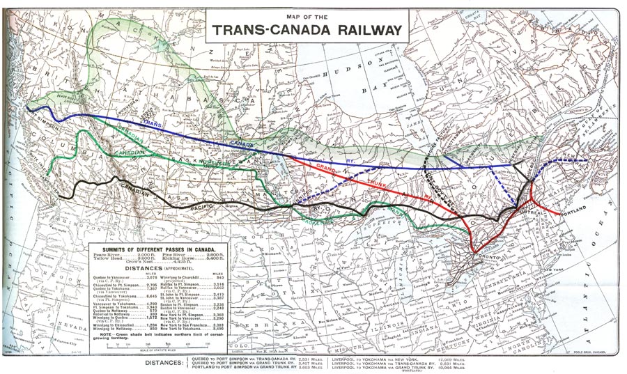
The mileage of the proposed railway, allowing the usual percentage for loss in curvature, will compare as follows with other existing routes : (Miles)
Quebec to Vancouver (C.P.R.) - 3078
Quebec to Port Simpson (Trans-Canada Railway) - 2830
Chicoutimi to Port Simpson (Trans-Canada Railway) - 2705
Quebec to Yokohama (via Vancouver) - 7367
Chicoutimi to Yokohama (via Port Simpson) - 6645
Winnipeg to Quebec (C.P.R.) - 1572
Winnipeg to Quebec (via projected T.C.R ) - 1410
Winnipeg to Chicoutimi (via projected T.C.R.) - 1284
Average summer temperature at all the principal points between Quebec and Port Simpson. (From returns kindly furnished by Mr. R. F. Stupart, Director of Meteorological Service at Toronto) : (In 1895)
Moose Factory, James Bay - 61
Quebec - 63
Rimouski - 55
Chicoutimi - 60
Winnipeg - 62
Norway House - 59
Oonikup - 60
Edmonton - 60
Athabasca Landing - 55
Dunvegan - 57
Port Simpson - 55
ADVANTAGES OF THE PROJECT.
The Advantages of the Proposed Line have been briefly enumerated in the Memorial presented to Sir Wilfrid Laurier by the Quebec Board of Trade on the 16th February, 1901, from which I extract the following :
1. Distance—The distance from Quebec to Port Simpson would be 250 miles shorter than that from Quebec to Vancouver by the C.P.R., and from Chicoutimi to Port Simpson 370 miles shorter. The distance from Chicoutimi to Winnipeg would be 290 miles shorter than from Quebec (C.P.R.) to Winnipeg, The distance from Chicoutimi to Yohohama would be 720 miles shorter than from Quebec to Yokohama by C.P.R.
2. Gradients—The summit of this line, in the Pine or Peace River Pass, would be about 2,000 or 2,800 feet above tide. The C.P.R summit, further south, is 5,400, and one of the American Pacific roads reaches an elevation of 11,000 feet. The summit between the St. Lawrence and James Bay is less than 1,200 feet, and the approaches to both summits are so gradual that there should be no difficulty in obtaining a maximum gradient of one per cent, from ocean to ocean, and possibly the maximum of 6-10ths of 1 per cent., which is now so eagerly sought for by American Trunk lines.
3. Seaports— The harbor of Port Simpson is said to be the finest on the Pacific Coast north of San Francisco. Nottaway is the only deep water harbor on James Bay, and with some dredging can be entered by vessels drawing thirty feet. The coast line of James and Hudson Bays tributary to this railway, will be about 4,000 miles. Chicoutimi (six miles below the town) can be reached by vessels of any draught, and Quebec has magnificent docks, which have cost the Government $3,000,000, with deep-water berths and elevator facilities for steamships drawing (should such draught be necessary hereafter) 40 feet of water. It is thought by many that Québec or Chicoutimi can be made a winter port for ocean vessels of suitable construction. The Baltic until a few years ago was closed, like the St. Lawrence, all winter. Now it is regularly and safely navigated all winter by many steamers carrying from 5,000 to 8,000 tons of freight, and with no difficulty as to insurance. During any time that these ports may be inaccessible in winter, the bridge now being built at Quebec will give this railway short and easy access to the winter ports of Halifax and St. John.
4. Climate—The least favorable climate to be met with on the proposed line will be that of the country between Lake St. John and James Bay. Recent information goes to show that this has been entirely misrepresented. Observations taken at Moose Factory, on James Bay, prove that the average summer temperature during five years was somewhat warmer than Chicoutimi and three degrees warmer than Rimouski, and that the average snowfall was half that of Montreal. So that from a climatic point of view anything which can be grown at Rimouski, Chicoutimi or Winnipeg, can be grown in the James Bay territory.
5. Soil—Recent explorations prove that the soil in the James Bay territory is equal to that of the St. Lawrence valley. That of the immense Peace River valley is well known for its fertility, and present information goes to show that a large portion of the country between James Bay and Lake Winnipeg and between Lake Winnipeg and Peace River, is also excellent. So that it may be said that the whole country from the Saguenay to the Rockies is fit for settlement and for the raising of cereals, and could support a population of many millions, sufficient, in fact, if the zone between this line and the C. P. R. were settled, to raise breadstuffs for the British Isles, and make them independent of all foreign countries.
6. Minerals and Timber—The reports of the Geological Department indicate that this country is rich in minerals. The best of iron is found in the James Bay country, together with lignite coal and copper. The district north of Peace River abounds in petroleum, and the country between the Rockies and the Pacific Coast in bituminous and anthracite coal, gold and copper, and a branch from this line would offer the shortest route on Canadian soil to the Yukon gold fields should a railway ever be needed in that country. The James Bay district and the country east and west of Lake Winnipeg are timbered with the best spruce. The best of iron is found in the James Bay country, and the rivers abound in water-powers to convert the timber into pulp and paper.
7. Military and Naval—In the event of hostilities with our neighbors, which it is sincerely to be hoped may never occur, the present C.P.R. line and all our telegraphic communication with the west could be broken in twenty places in a week, and communication would never be restored. The proposed line being from 300 to 400 miles from the frontier, protected by fleets at Quebec, Saguenay, Nottaway and Port Simpson, would be impregnable, and for this reason should receive the support of the British Government. This support need not be costly, as the price of a battleship per annum would pay the interest on the cost of the whole undertaking.
8. Manitoba—A branch to Winnipeg would give the Province of Manitoba its shortest and cheapest outlet to the seaboard. The saving in distance, the level character of the road, and the consequent easy gradients, would, it is estimated, make it profitable to haul wheat to the seaboard at seven cents per bushel less than it now costs the farmer of Manitoba. This saving, even on the present crop, would more than pay the interest on the cost of the road. Should the navigation of Hudson Straits ever prove practicable, the distance from Winnipeg to the Straits via Nottaway would be no greater than via Churchill, and through a much better country.
For all these reasons we think that the line indicated on the enclosed map would be the best that could be built, from an Imperial as well as Canadian point of view, and it should not be forgotten that for its entire length it will pass through a country between latitudes 47 and 55, or in the same geographical position as Paris, Berlin and Warsaw in Europe.
The great financial success achieved by the Canadian Pacific has rendered it much easier to secure capital for such an undertaking as this than it was twenty years ago, and the project should not have the antagonism of the capital interested in the Canadian Pacific, as it must be beneficial to that road by putting population into the zone of country between the two lines.
We have reason to expect that the Province of Quebec will grant a subsidy of land, probably 20,000,acres per mile, for the first section of the railway from Lake St. John to James Bay, about 380 miles, and it is hoped that the Province of Ontario may grant a similar subsidy from James Bay to the western boundary of the Province near Lake Winnipeg.
If the Dominion Government would grant the usual double subsidy of $6,400 per mile, it is believed that a financial basis would be established which would secure the necessary capital to carry out this most important undertaking, which will make Canada a solid country with breadth and great agricultural resources, instead of a fringe of settlement subject, as it now is, to the good-will—from day to day— of our powerful neighbors to the South.
Where the line passes through forest lands it would, of course, be expected that the Dominion will grant a land subsidy.
On this financial basis the promoters of this enterprise would be prepared to suggest the following advantages to Canada, advantages which have never yet been offered to the country by any other railway corporation :
1. To construct the entire road with steel rails and steel bridges of Canadian manufacture, thus offering to the new steel and iron works at Sydney, Midland, Sault Ste. Marie and Hamilton an immediate market for an immense quantity of steel.
2. To give free transportation from Quebec to any point on its line for all immigrants and bona fide new settlers and their effects.
3. To carry wheat from all points on its line in the Province of Manitoba to the ocean steamer at Chicoutimi or Quebec for nine cents per bushel, thus saving the farmer of Manitoba about seven cents per bushel on present freight rates to the seaboard.
I have the honor to be, Sir, Your obedient servant,
(Signed,) GEO. TANGUAY,
President Quebec Board of Trade.
Let us now look at some of the authorities for the statements contained in this memorial of the Quebec Board of Trade :
Translation of a letter from the Rev. Father Nedelec, late Missionary at James Bay.
Mattawa, 15th November, 1887.
J. G. Scott, Esq., Quebec.
Dear Sir,—I beg to acknowledge receipt of your letter of the 8th inst., in which you ask me for information about the vast Hudson's Bay territory—the Siberia of Canada. In order to answer your questions satisfactorily one would have to be an explorer, a geologist, a mineralogist and even a farmer, in a word, an expert in every branch of knowledge. I confess that I am only a missionary to the Indians and the shantymen of the Ottawa. Nevertheless, I shall always esteem \t a pleasure and a duty to oblige you to the utmost of my capacity,
to the depth of knowledge and extent of my observations. Beyond this, I can but refer you to good authorities on each subject. But to answer your questions :
1st.—The country is generally habitable, excepting a few places, chiefly along the coast. Along the east coast the fishing is good.
2nd.—All kinds of grain, except wheat and buckwheat, also fruit and vegetables, are, as a rule, grown with success, except in a few scattered places on the coast.
3rd.—I find it difficult to say what population might be supported in the territory. There is room for millions, with improved agriculture and the development of industries.
4th.—The extreme heat is 100 degrees, and extreme cold on the coast—55 degrees. Average in January, 3 degrees.
5th.—In some places the climate is better than that of the north of Germany, Poland, Norway, north of Scotland, Lake St. John, Newfoundland. In some parts the natural resources are magnificent, in others not so good. As a general rule it resembles Quebec and the district of Lake St John. All that I can say is that the country is larger and more habitable than can be imagined.
6th.—The soil in general is of clayey nature.
7th.—Between Lake Temiscaming and height of land, white and red pine, spruce and soft birch abound ; on the other side of the height of land, spruce, soft birch and cedar.
8th.—Any amount of fur, birds and fish ; whales also abound.
9th.—The snow-fall is not excessive.
SUCH IS HUDSON'S BAY.
What was Canada 200 years ago ? What were the United States ? In my opinion it would be a good thing for the Province of Quebec to take possession of that part of the Hudson's Bay that belongs to it. Your Company ought to establish Acadian settlements in the Bay. They are the very people for the country.
Yours truly,
(Signed) J. M. NEDELEC, O.M.I.,
Indian Missionary.
The Rev. Father Paradis, formerly Missionary at Moose Factory, writes in a similar strain and says :
Game:—Wild geese and duck are abundant. At Fort Albany, north of Moose Factory, 36,000 geese are killed there annually for provisions for the Hudson's Bay Company by Indians, that being the number they are expected to furnish.
I think this country might be compared to Germany in Europe, and the Fort Albany district with Russia.
The climate resembles that of Kamouraska, with the same flowers, wild fruits, such as gooseberries, strawberries, juniper berries and cranberries.
At Moose Factory there are some splendid gardens, containing currants, gooseberries, and all kinds of vegetables. In one of them there is an ash tree planted 10 years ago that now measures 13 inches diameter.
Ice leaves the rivers about end of April, and the Bay is navigable from 5th to 13th May. Closes from 1st to 20th November. The highest tide is 10 feet.
LETTER FROM PROFESSOR BELL.
Head of the Geological Survey Department,
Ottawa, 7th March, 1887.
J. G. Scott, Esq., Quebec.
Dear Sir,—Your favor of the 4th reached me this morning, and I beg to answer your questions seriatim as follows :
1. A considerable portion of the territory southward of James Bay is fit for settlement.
2. My own explorations have not extended eastward of the basin of Moose River. In that Basin a great deal of good land is found between the water shed of the great lakes and the commencement of the low level country to the south westward of James Bay. This would
comprise about one-third the region between Lake Superior and James Bay. The soil is mostly brownish gravelly loam and light colored clay, with sand in some parts. In the coniferous forests, when the ground is level, the surface is apt to be covered with deep moss, but when this timber has been burned off and replaced by deciduous trees, the ground is dry.
3. The summer and winter temperatures resemble those of the County of Rimouski. The summers not so hot, nor the winters so cold as at Winnipeg.
4. The average snow-fall is about three feet or a little more, still not quite so great as about the city of Quebec.
5. Potatoes and all other kinds of root crops have been found to do remarkably well. Hay also grows luxuriantly. Barley would, x think, be a sure crop every year, and rye could also be grown with advantage. Barley is sown every year at Moose Factory and Rupert's House, and it has ripened well every year that I have visited these parts. Still it is said to fail some years. However, these places are much further north than the region I have indicated, and what is worse for them, they are near the sea, which is said to have an unfavorable influence in the autumn. Mr. John McIntyre (now at Fort William) says he has ripened wheat at Missinaibi and New Brunswick House, within the above area. I have had experiments made fit New Brunswick House and at Norfolk, on the Abittibi River, with a great variety of field and garden seeds, and the results proved that this region is capable of growing anything which can be raised, say in the County of Rimouski. I regard the region as well suited for stock raising and dairy farming, and it is not unlikely to prove fit for grain also.
The soil at Moose Factory is heavy and cold, still vegetables, etc., grow successfully here. Among the kinds may be mentioned potatoes, beans, peas, turnips, beets, carrots, cabbage, onions, etc., etc As showing the absence of summer frost at Moose Factory in 1877, I mention at page 27c of my report for that year, that, on our return to Moose Factory (from the North) in the end of September, we found that there had been no frost there all summer, and the most tender plants, such as beans, balsams, melons, cucumbers, tobacco, the castor oil bean, etc., growing in the open air, were still quite green and flourishing. That summer was, however, probably a finer one than usual.
It has been objected to this statement by some Hudson Bay Co.'s men, that I should have mentioned that some of the above plants had been started in the house. But all I wanted to show was the absence of summer frosts that year. These plants are generally started under glass in other parts of Canada as well.
6.—White and red pine grow in the southern part of the basin of Moose River, but the timber, most abundant throughout the whole country, consists of white and black spruce, tamarac, white cedar (as far north as Moose Factory), white birch, aspin, rough-barked poplar, “Jack” pine and bouleau. There is a little elm, and black ash, in the southern part, but it is not worth counting commercially. Some of the above woods are worth exporting.
7—Minerals are to be found in this region; nearly all the metals are to be looked for in the Huronian formation, a belt of which is believed to run all the way from near Lake Abitibi to the south of Lake Mistassini, and this would be crossed by any railway from Quebec to James Bay. Iron and gypsum are abundant to the north-west of Moose Factory.
The shores of Hudson's Bay, that would be tributary to the projected railway, afford a variety of useful minerals in paying quantities.
8.—Coal cannot be said to have been found in the region under consideration. I found lignite in various places on the Missinabi and Moose Rivers; also indications of it on the Mattagami and Albany Rivers, but the quality was mostly inferior, and in a well-wooded country like this, would not be in demand for fuel. I also found anthracite on a long island on the east coast of Hudson's Bay, but I do not think the quantity likely to prove great, although the quality was first class. As far as we are yet aware, there is a chance, geologically speaking, of finding coal in the islands on James Bay, but we have no evidence, as yet, of its actual existence there.
9.—Among the fish found in James Bay and Hudson's Bay may be mentioned a fine white fish, lake trout of Lake Superior, and some smaller species, sea trout, salmon, rock cod, capling, etc., besides strictly fresh water fishes in the rivers and lakes, such as speckled trout, Backs' grayling and pickerel, pike, etc. The fisheries of the bay will probably be found to be valuable. The oil-producing animals, such as seals and porpoises, may be included under “the fisheries.”
I am, dear Sir, yours truly,
(Signed) ROBERT BELL, CE., M.D.
ANOTHER LETTER FROM PROFESSOR BELL, Geological Survey Department :
Ottawa, August 30, 1902.
Dear Mr. Scott,
I thank you for your letter of the 27th inst., and the copy of the new edition of the prospectus of the Trans-Canada Railway. It is very well gotten up, and contains much valuable information. Your line on the map showing the northern limit of the growth of cereals is
not too far north. In fact it almost corresponds with the north limit of possible wheat culture. I have had wheat ripened for two years at Waswanipi, S. E. of Rupert's House.
As the existing railways will probably be unable to move the phenomenal grain crop of Manitoba and the N. W. Territories this year, the present ought to be a favorable opportunity for promoting your Trans-Canada Railway.
Very truly yours,
(Signed) ROBERT BELL.
I will not read the reports of Mr. Henry O'Sullivan on this country as he is here himself to tell you about it, and when you hear him you will lam sure admit that his exhaustive explorations of that immense country, so difficult of access, have entitled him to the distinguished honor which he has had of being made a Fellow of that great institution, the Royal Geographical Society of London, the only native born Canadian, I think, who enjoys that distinction.
The feeling of the North-West members on the subject of additional railway facilities and lower freight rates may be judged from the following :
Extract from Speech made by Mr. T.O. Davis, M.P. for Saskatchewan, in the House of Commons at Ottawa, in March 1902, on the Question of the Transportation of Grain.—Taken from Hansard.
"What we want is a continuous line of railway, which can be operated 12 months of the year, and double track if necessary. Last year four hundred thousand people in the West produced 100,000,000 bushels of grain. We are going to get people m there at the rate of 100,000 per year and in eight or ten years the production of the country will be increased to 400,000,000 or 500,000,000 bushels. Wheat will have to be carried to the seaboard, and that cannot be done over our canals, when they are frozen up six months m the year. What we want is to be able to put our wheat on the car and run it through to the seaboard. There has been too much money spent on trying to create an artificial port trying to make an ocean port out of something that was never intended to be so by nature. If half that money had been spent on the port of Quebec in providing proper facilities there—where we have a port that can float the largest sups that will be built in the next twenty years—and if we had a railway running from the centre of the Territories right into the port of Quebec, from where our produce could be shipped twelve months in the year, you would not hear anything about the car shortage we hear so much about at present.
Then we have to take into account the depreciation in the value of wheat and the charges for interest and insurance if it has to be stored over during the winter, which must amount to at least six cents per bushel. There is also this further point to be considered. If we have to depend wholly on our canals, we will have to store an immense quantity of wheat in the elevators at the head of Lake Superior, and when navigation opens in the spring and we throw that on the markets of the world, down goes the price, so that our farmers will be out, not only the loss in storage and insurance, but also the depreciation in value on account of such an immense quantity being thrown on the market.”
The Right Rev. W. Carpenter Bompas, D.D., Bishop of Selkirk, who has lived nearly all his life in the Territory in question, says :
“The line you propose for your railway is exactly that which I would have desired to open up the vast territories in which I have been most interested and partly resident for the greater part of my life. The huge sealed wastes, formerly known as the Hudson's Bay territories, are, I trust, now destined by your railway to be opened to civilization. I cannot imagine any plan so well adapted to enlarge widely the boundaries of the habitable earth.
"The approach of your railway to Hudson's Bay I think most valuable in every way, both in the way of commerce and in defence of the Dominion if needful. Your further course by way of Norway House, Green Lake, Athabasca Landing and Lesser Slave Lake, I deem very advantageous in the way of commerce and partly for settlement of the country, and especially as a route of communication with the far north country of Mackenzie River and the great northern lakes, Great Slave Lake and Great Bear Lake, with their fine fur countries and the rich timber and oil country of Athabasca.
"Then you come to Peace River, which I deem one of the chief gems of the whole Dominion. I think it certain to be settled up as soon as your railway reaches it. It has been a shame that so fine a country should remain unsettled only for want of means of communication with it.
"You then pass the Ominica gold mines, which are now again successfully worked, and when I descended the Skeena River, I" learned that the whole country from Peace River to Port Simpson was a level tract admirably suited for carrying a railway through it.
"The route of your railway is just what I could have wished. I cannot be otherwise than interested in your success, because your railway offers ground for expecting the realization of a long cherished hope that those vast northern regions would yet emerge from solitude and desolation into life and activity.
"I deem your project admirable and bound to succeed."
I will now give a few extracts from a most valuable pamphlet on the James Bay territory published by a clever, laborious scholar, who has given the subject much thought and labor. I refer to Mr. Chrysostôme Langelier, the Secretary of the Colonization Commission of the Provincial Government. Mr. Langelier says :
"In the first place as to climate, that the official reports show the average summer temperature of the following places to be, as compared with northern Europe :
Moose Factory, James Bay - 62.31
St. Petersburg, Russia - 60.06
Stockholm, Sweden - 60.40
Bergen, Norway - 58.60
Christiania, Norway - 59.70
"In the estimation of many people Hudson Bay is but a portion of the Polar regions. This is a mistake, a serious mistake, since no part of the great basin enters into the Arctic circle, and its southern latitude happens to be south of that of London.
"Including James Bay, which forms its southern extension, Hudson Bay is about one thousand miles in length and more than six hundred miles in width at its northern extremity. Its total area comprises about five hundred thousand square miles, or more than half that of the Mediterranean.
(Evidence of Dr. Thompson, before the Parliamentary Committee in London.)
"I spent a winter at New Brunswick Fort (on Missinabi River), says Gladman in his evidences, the first year of my engagement in the Company, 1814. At this post the soil is good. Excellent potatoes, as well as all kinds of vegetables were grown there. Oats matured well and made good flour, ground by a steel hand mill. Barley also succeeded well. At this period, in 1814, wheat had not been tried. Since then, as I am informed, the experiment of this cultivation has been tried with good success. Horned cattle were raised and stabled during the winter." (This point is about midway between Lake Superior and Moose Factory.)
Barnston, who has resided at Martin's Falls, two hundred and fifty miles from the mouth of the Albany River, up to which point the river is navigable for steamers, affirms that "during winter this locality has the temperature of Russia, and that of France and Germany during the months of July and August. In ordinary seasons the trees begin to bud about the 12th of May, and the leaves are in full growth at the end of the month. They yellow and begin to fall in the beginning of October."
Of minerals Mr. Langelier's pamphlet says :—
"But the mines are nothing as compared to those of the islands of Nastakopa Strait, where manganese or? has been discovered in inexhaustible quantities. In one of these islands, which form a chain of more than 90 miles in length, this deposit of ore forms on the surface to a depth of twenty feet. Those deposits are rich enough and of sufficient extent to furnish at least 40,000,000 tons of iron.
"The copper mines of Abatagoman Lake contain great wealth, which may be utilized when the region is served by a railway extending from Quebec to James Bay. The copper deposits cover an extent of several square miles, and the extraction of the ore is comparatively easy and of low cost, as the copper bearing rock forms the upper strata of the land.
" The climate throughout the whole extent we have stated as susceptible of cultivation, is good and even warmer in the region of James Bay than in Manitoba and the North-West Territories. The agricultural season, that is, the period free from frosts, is longer at Moose Factory than at Winnipeg, longer than the district of Muskoka and as long as in the largest portion of the Province of Quebec. The fact that the flora in the neighborhood of Moose Factory are the same as those in the neighborhood of the Province of Quebec, shows clearly that the climate must be almost the same in the two localities.
"The most beautiful portion of this territory is the southern portion, or James Bay, which contains at least 108,800,000 acres of very good arable land, forests of a greater extent and almost as rich as those of the Province of Quebec ; mines of lignite, gypsum and iron of great value, and which will support in ease and comfort a population of at least ten million people once it will have been given a means of easy communication with the great commercial centres by the construction of a railway.
"Apart from agriculture the section has resources that warrant its settlement and development. It is a wonderland of mineral richness. To the extreme north of the section and extending into the barren lands are the copper deposits that give indications of most unusual richness. Along many of the rivers, but more particularly the Athabasca, are exudations of mineral pitch. Wells 12 feet deep, dug for the purpose, have been speedily filled with pure pitch, which is used for caulking boats and the like. But the pitch is chiefly valuable because it indicates inexhaustible supplies of petroleum. Near Fort Chipewyan are immense beds of pure gypsum. On the north shore of Lake Athabasca are large deposits of plumbago. The outcroppings on the surface are of such fine quality that strips of it are cut and used as lead pencils by servants of the Hudson's Bay company. The deposits of lignite and bituminous coal are enormous. Beds of lignite, four and five feet in thickness, occur at the great bend of the Athabasca, all down the Buffalo river also, as far as Fort McMurray, in fact almost everywhere there are outcroppings of coal. Natural gas has also been found."
The following is extracted from a recent issue of a Winnipeg paper :—
" In the Peace River valley the luxuriance of the vegetation, the broad sweep of the river, occasional heavy belts of timber and breaks in the high banks caused by the inflow of the many tributaries of the Peace, make a picture that neither time nor distance ever effaces from the memory of the beholder. The country south of the Peace River to the Alberta boundary, in its eastern part, is a parkland, with many forests, streams and rivers, and a number of lakes, of which the Lesser Slave is the largest ; to the west is the Grande Prairie, which is practically identical with the Red Deer country of Alberta."
CLIMATE OF THE PEACE RIVER.
The following extract from the journal of Sir Alexander Mackenzie, who passed the winter of 1792 and 1793 on the Peace River, near Dunvegan, is very interesting :
"At the end of January very little snow was on the ground, but the weather was cold until about the 16th of March, when it became mild, and by the 20th of April the gnats and mosquitoes came, and Mr. McKay brought me a bunch of flowers (anemone patens). On the other side of the river the plains were delightful, the trees were budding and many plants in bloom. The change in the face of nature was as pleasant as it was sudden. "In the years from 1873 to 1879 the average opening of the Peace was April the 21st, while the average opening of the Ottawa River, from 1832 to 1870, is given as April 30, and the average opening of the Red River for many years has been no earlier. The average length of sunshine during the summer season is eighteen hours per day, the average summer temperature about 75 in the shade, and this weather lasts from about the 1st of May to the end of September. Horentzky, in a note to his report made in 1872, says, "September 29, rested for noon lunch ; thermometer 75 in the shade."
STOCK RAISING AND GRAIN GROWING.
"It is a stockman's paradise, thousands of acres of fine pasturage where the cattle and horses can remain out all winter. The horses of the Hudson Bay posts in this section are regularly wintered out and turn up fat and sleek in the spring. Then again there are miles of splendid Kentucky blue grass, growing to a height of from five to eight feet, the finest hay that it is possible to produce. Then as to cereals : The wheat that took the first prize at the centennial exhibition of 1876 was grown at Fort Vermilion, on the Peace River, a point at least 150 miles further north than where the new road will run."
A great advantage offered by making Port Simpson the Pacific terminus of the railway will be its proximity to Alaska. A very large trade is now done between San Francisco and Seattle and Alaska by a dangerous coasting navigation. This traffic must come over the Trans-Canada when completed.
But much more important than this is the Japan and China trade. As before stated the distance from Quebec via Port Simpson to Yokohama will be more than 600 miles less than by the C.P.R , via Vancouver, and from Liverpool to Yokohama by Port Simpson 2,200 miles less than by New York and San Francisco. Mr. J. J. Hill, the railway magnate, who controls the Northern Pacific and Great Northern, is so satisfied with the advantage of his route in distance, as compared with San Francisco, that he is building two immense steamers of 26,000 tons capacity with which he expects to control the Japan trade. Where will he be in competition with the Trans-Canada, whose route will be 700 miles shorter than his ?
The British Government has just concluded an alliance with Japan. The shortest, safest and quickest way to send troops from England to Japan will be by the Trans-Canada. So this line is of Imperial importance.
The wheat belt of the North-West stretches from the U S. boundary to latitude 61, a distance of about 700 miles, and 14 degrees further north than Quebec. The warm winds carried by the Japan current, the gulf stream of the Pacific, cause this. This wheat belt is shut off from Eastern Canada by Lake Winnipeg which stretches north almost from the U.S. boundary to the northern limit of wheat cultivation in that longitude. Consequently all railways to or from Eastern Canada must pass either north or south of this great lake. If the Trans-Canada is not built and if the Government decide that all railways must pass south of Lake Winnipeg, the future railway system of this wheat belt—and it will require many roads—will consist of north and south lines. Such lines must inevitably send their traffic to the Unites States. Already Minneapolis is grinding immense quantities of Manitoba wheat, which could just as well be ground by the great water-powers of the James Bay Rivers, and the flour then sent on to Europe by Quebec. American settlers are going into the North-West at the rate of 50,000 to 60,000 per annum. If Eastern Canada does not soon offer the best and shortest route to the St. Lawrence, and much cheaper freight rates on grain than now prevail, what is likely to be the political future of the North-West ? Is there not a possibility of disruption ?
Halifax and St. John are just as vitally interested in this question as we are. A very large proportion of Manitoba grain is now shipped to Europe via Buffalo and New York, and some by Portland. Unless a shorter and better route is offered it will continue to go that way. The Trans-Canada offers the shortest and best route not only for Quebec and Montreal, but also for Halifax and St. John. In fact Halifax and St. John have nothing to expect from any other line but the Trans-Canada.
There are two men in Canada whose opinions as to the best route to be followed for the next transcontinental railway should have more weight than those of any others. I refer to Sir William VanHorne and Sir Sandford Fleming.
Sir Sandford Fleming, the most celebrated engineer in Canada, or perhaps in America, who has just completed the great project of a Pacific telegraph cable from Canada to Australia, and who has an intimate knowledge of the whole of the country to be traversed by the Trans-Canada, was interviewed by a reporter when it was announced that the Grand Trunk Railway contemplated building a transcontinental road.
His opinion, which follows, is a remarkable confirmation, by the greatest known authority, of the wisdom of the selection of the route provided for in the Trails-Canada charter.
"I am inclined to think Mr. Blair is on the right track in proposing to extend the Intercolonial Railway to the Pacific. It seems to me, however, that it would be a mistake to try to form a new transcontinental line in a haphazard way by connecting various fragments of railway which have been located without any general plan. The effect would be to lengthen the whole line and unduly lower its engineering character, and almost certainly give it features which would be forever regarded as blemishing to a great transcontinental line. To realize Mr. Blair's conception of a new national railway, it should, in my judgment, begin at the Quebec Bridge, now building, where it would form a direct connection with the Intercolonial, and it should extend from Quebec by the most direct route to Port Simpson on the Pacific. From what I know of the general character of the greater part of the intervening distance I believe a line with splendid engineering features could, with ordinary care, be secured. It would pass away to the north of the rugged shore of Lakes Huron, Superior, Nipigon, and Winnipeg, through a vast region reported generally of alluvial soil, with abundance of wood and water.
"First—The Quebec Bridge is in progress, that structure I have always favored, but it would have been a bold man to have proposed such a work a quarter of a century ago. The Quebec Bridge will give the needed connection with the Intercolonial as well as the Grand Trunk Railway, and along with a junction with these railways access and egress to and from Atlantic points at all seasons.
"Second—The greater part of the vast region through which the new line might pass between Quebec and Port Simpson is woodland, and we have to-day a new value given to the timber, which was undreamed of 25 years ago. The territory to be traversed is the natural home of pulp-wood, and in this vegetable substance the unoccupied regions of Quebec and Ontario have an inexhaustible crop ready for harvesting. A crop of a perennial character, which, in extent, I venture to say, is unsurpassed in the North American Continent—perhaps in the whole world.
"I have already expressed my doubts as to the wisdom or expediency of proceeding in a haphazard way to establish a new transcontinental railway. I regard the shortest line obtainable between the tide-waters of the two oceans as quite long enough. For that and other cogent reasons I would advocate the most favorable route which can be had between the port of Quebec and Port Simpson for a new Dominion Grand Trunk line, and at the same time to have in view the establishment of railway service with all desirable points by branches judiciously laid out. By having regard to these leading principles, great advantages would, in my judgment, result. It seems to me there is ample room for the new railway. It would in no way interfere with any other line, and it may be regarded as a natural development of the railway system of Canada. I am satisfied that it is possible to establish a splendid national railway on the route proposed with the best ocean ports at its termini. With a Rocky Mountain passage very much lower than that of any railway yet constructed across the North American Continent, and with general engineering features even more favorable than those obtained on the Intercolonial Railway, such a line would give breadth to Canada and admit of settlements and profitable industries where such are not now possible. In the far North-West it would open up for ranching the rich plains of the Peace River and Northern British Columbia, and render the more distant gold fields more easily accessible at all seasons.
"When the day arrives to open the railway as a through route it will be found to possess advantages, in respect to distances, as compared with the route via San Francisco and New York. From Yokohama to Liverpool the passage across the Pacific Ocean would be 605 and across the Atlantic 195 nautical miles less. While the land distance would be 502 statute miles less, making a total saving on the whole distance of about 1,423 statute miles.
"Regarded simply from a Canadian standpoint, I cannot conceive any public undertaking which would better meet the wants of the New Dominion, throughout its whole extent. I rejoice to know that it has so soon in Canadian history been brought up for serious consideration."
Sir Wm. Van Home says :—"The direct line from Quebec to the Pacific coast, as laid down on the map, would not injure the Canadian Pacific in the least degree—on the contrary, it would benefit the Canadian Pacific in many ways."
"The position of the Canadian Pacific Railway is absolutely unassailable. For that reason it is our policy never to oppose anything. The Trans-Canada road has started with better prospects than the Canadian Pacific had once. When the Northern Pacific road was built, everybody thought it was way up north beyond nowhere. Then the Great Northern was built, and people promptly forgot thinking of the Northern Pacific as far north. Then came the Canadian Pacific, and that seemed to run through the Arctic regions. We would hail with delight a parallel route from Atlantic to Pacific to help us develop the country. There is enough of it up there for us all."
I would remark that when Sir Sandford Fleming was interviewed by the Star reporter he did not know of the existence of the Trans-Canada charter. And yet that charter follows exactly the line, mile for mile, that he lays down as being the best line from a national, a patriotic and from every other point of view. We have selected, as he suggests, the shortest and best route for the main line and branches to Winnipeg, to Toronto, to Ottawa, to Montreal and to Chicoutimi— some of which are partially constructed already—will serve the best interests of every port of Canada and of every Canadian Province, and yet will keep its export trade for Canadian ports exclusively. It has been suggested that Mackenzie and Mann's line should be extended from Port Arthur, on Lake Superior, to Gravenhurst, near Toronto, alongside of the C.P.R. But that line runs partly through the State of Minnesota, so it would be useless for military purposes, and the South African war has taught us how important a factor a railway is in modern warfare. But apart from this, what would be gained by building 750 miles of additional railway around the rugged shores of Lake Superior and Lake Huron, where there is neither agriculture nor lumber to feed the existing line ? Why not put these 750 miles of new road into the good country further north, which is thirsting for railway communication ? In any case Mackenzie & Mann's line was built specially for the development of the Saskatchewan country. Why should wheat grown on this line in latitude 54 be dragged south to Toronto in latitude 44, and then north again to the mouth of the St, Lawrence in latitude 52 ? More especially so when a short branch from the Saskatchewan to the north of Lake Winnipeg would reach the Trans-Canada and give the Canadian Northern an outlet to Quebec 500 miles shorter than the route via Port Arthur, and Gravenhurst ?
Some people pretend that the Trans-Canada runs too far north, forgetting that wheat comes to maturity at latitude 61 on the Mackenzie, and that the most northerly point touched by the railway will be latitude 56. To such objections the best answer is the statement made to the Quebec Board of Trade by Colonel Church, of London, the originator of our project, to the effect that last year the Hudson Bay Company sent in thirty thousand dollars worth of the most modern flour mill machinery to Port Vermilion, on the Peace River, and although that settlement is 200 miles further north than the Trans-Canada line, yet it is lighted by electricity. And if we are too far north, what will be thought of the Toronto people, who have just given notice of application for a charter for a double track road from Winnipeg to Seven Islands, on the Lower St. Lawrence, 1,400 miles long, which will pass away north of Lake St. John ?
Notice has been given in the Official Gazette that incorporation will be sought for a company to be named the Grand Trunk Pacific Railway for a road from Gravenhurst or North Bay to Port Simpson. None of this line would be in the Province of Quebec, and three-fourths of it—from Lake-Winnipeg to the Pacific Ocean—would be on ground already given by Parliament last session by charter to the Trans-Canada. We feel quite sure that Parliament would never consent to such an unjust infringement of our rights, until a reasonable time should be given us to carry out the work, and we may feel sure that the citizens of Quebec may be satisfied that their just claim to this great public work and to its existing charter will not be ignored so long as Messrs. Laurier, Parent and Fitzpatrick are there to represent them.
In any case we are going on with our work, aided by splendid and daily increasing subscriptions from our fellow-citizens, who are showing a spirit never before witnessed in Quebec, backed up by the sympathy of the Maritime Provinces, as expressed by their political representatives who were here a few days ago, and firmly believing that although we may seem small people to carry out so great an undertaking, yet we have justice as well as geography on our side, and justice must prevail, and believing that the gentlemen who have by constructing the Lake St. John and Great Northern roads put life and activity and industries and population into the northern half of the Province, and have brought back trade and hope and confidence to our city, may perhaps be trusted to try the same thing on a larger scale. The photographs which will be exhibited this evening will give you some idea of what has been done in the north of the Province.
It would seem from the tone of the English press that they are not satisfied in the old country because Canada does not contribute like the other colonies to the cost of the Imperial army and navy. It may seem hard to the English tax-payer that we should have the protection of these costly arms and contribute nothing, but there is to some extent a feeling in Canada that we must not drift into militarism. Be that as it may—what better or more loyal answer could we make, what better contribution could we give the Empire than the construction of this road, which, if needed, could become a great military line of railway, remote from the frontier at every point from ocean to ocean, impregnable, and exempt from the dangers which menace existing and projected lines at Lake Nipissing, at Lake Superior and on the Minnesota frontier, the shortest possible line by hundreds of miles from tide water to tide water, recommended by the highest railway and engineering authorities in the world, the best and shortest line for the transportation of troops and supplies from England to Japan, passing through a country susceptible of cultivation from one end to the other, where a loyal British population could raise, in the greatest wheat belt in the world, breadstuffs to feed the whole Empire, in short, a railway which would convert Canada from being a source of Imperial weakness and anxiety into one of Imperial strength. The Province of Quebec is deeply interested in this question because the Trans-Canada will pass through the centre of the seventy millions of acres of land recently added to the Provincial domain in the James Bay territory, and the Government have already been offered enough money for less than half this land—in the event of the construction of this railway—to pay off the public debt, which is now such an incubus on the Province, retarding its progress and preventing it amongst other things from giving reasonable help, as it formerly did, to scientific and charitable institutions.
Mr. Chairman, there is in the heart of every loyal Canadian a soft spot for the rugged old fortress which has been the birthplace of civilization on this continent, the cradle of Canadian liberty and patriotism, the citadel which has beaten back the tide of invasion when every other part of the country had been submerged, the city of which brave old Frontenac said that it seemed destined to be the seat of a great empire. Quebec's sons are scattered over the whole world, but "coelum non animam mutant qui transmare currunt" for wherever he is—be he a lonely rancher on the North-West ranch, a soldier earning distinction and honors in India or South Africa, "un Canadien errant, bani de ses foyers," in the gubernatorial chair on the Pacific coast, a great banker in the prosperous west, the son of Quebec feels a yearning in his heart for the Old Rock City, and knowing what is going on to-day, longs to be with us at this critical moment in the history of our city, and of our country. Nowhere, I firmly believe, is this feeling of reverence for the old city, which may be said to have made the history of this continent, better understood and appreciated than by the members of Parliament at Ottawa, and I am sure you will agree with me that we may rely upon fair play at their hands, and fair play is all we ask.
When Mr. Scott concluded his interesting lecture, the Chairman called upon Mr. O Sullivan, the well known surveyor, who added exceedingly interesting remarks regarding his personal experience in his exploration of the James Bay district from 1893 to date, showing that the proposed route was not by any means difficult for railway building. In 1897 he explored the country from Roberval to James Bay by canoe route and found the country rich in minerals, water-powers and remarkable lumber. He discussed the other proposed routes to the Pacific, but was satisfied that none could compare with the one surveyed for the Trans-Canada, which was wholly on Canadian soil, and would serve to promote the trade of the city and port as no other route could. Mr. O'Sullivan was at times witty, and his remarks fairly convulsed the audience with laughter.
During the evening many pictures, with the aid of limelight views, were thrown on a large canvas, showing the rich farms, thriving villages and towns, as well as water-powers in the Lake St. John district.
Before the meeting separated, Mr. Obalski, Inspector of Mines, explained in French the result of his visit to several points in the James Bay district, which contained valuable minerals, and to all appearances was well suited for agricultural pursuits as well as railway building.
On motion of Mr. T. Davidson, seconded by Mr. Gaspard LeMoine, a hearty vote of thanks was tendered Mr. Scott, to which the name of Mr. O Sullivan was coupled. Mr. Davidson, in proposing his motion, made a lengthy and interesting speech, in which he urged all Quebecers to unite as one man in support of the Trans-Canada Railway, which was bound to further, not alone the interests of the city, but also of the whole province. He also paid well merited compliments to Mr. Scott for his share of the work in promoting the Lake St. John and other railway interests.
In addition to a large number of ladies, who evinced the greatest interest in the topic under discussion, the following were among other gentlemen present: Sir James LeMoine, T. Davidson, Cy. Tessier, P. B. Casgrain, Lieut.-Col. Turnbull, Geo. M. Fairchild, jr., General Henry, W. C. Scott, E. Beaudet, O. Frechette, Dr. C.S. Parke, W. Lee, E. C. Wurtele, Chevalier Baillairgé, E. Gagnon, G. Hossack, Dr. Gale, Lieut.-Col. B. A. Scott, J.S. Budden, Major F. Lampson, P. Cotter, Jos. Winfield, W. Clint, G. Mitchell, Geo. Scott, E. Scott, Major Levasseur, E. St-George Boswell, G. LeMoine, E. Hunt, S. Hill, J. T. Ross, J. Bain, Capt May, Capt. G. Gibsone, G. Dunlop, Lieut.-Col. C. Lindsay, C. A. Pentland, K.C., E. Crean, Rev. A. T. Love, Rev. D. Grant, W. A. Marsh, Major W. Ray, E. A. Evans, D. McGie, E. G. Joly de Lotbinière, J. Glass, P. Johnston, G. Craig, J. Horan, J. Jones, A, Hardy, T. H. R. Gardiner, Prof. Gunn, M. Joseph, J. McCone, Messrs. McCone, Strang, Billingsley, Gastonguay, Lee, Stuart, Sidley, Robertson, Obalski, Dussault, etc., etc.
MR. HENRY O'SULLIVAN, CE., Fellow of the Royal Geographical Society of London, and Director of Surveys for the Province of Quebec, being present at the meeting, was asked by the chairman to give his opinion as to the nature and resources of the James Bay Territory, which he had explored several times for the Provincial Government.
Mr. O'Sullivan said :—
I arrived from Washington last night, where I went to attend a meeting of the American Forestry Association, and was surprised to see my name put so conspicuously forward on the invitation cards of the honored society, as one of the principals of the evening's entertainment.
It is true that before leaving for the American capital Mr. Scott showed me a letter from Sir James LeMoine, asking him to lecture, and my help in the matter, but I expected to be here only in the background, simply to supply Mr. Scott with any data I could glean from my different explorations on the country in question, and therefore have no prepared speech or lecture of any kind to favor you with.
However I feel that there are enough of data and ideas in this old head to make an interesting address if I can only express them. I will do my best however. If I may be allowed to use a thorough Irish expression, I believe I am the oldest engineer of my age in the country, for my connection with railway surveying dates back as far as 1853-4, when I worked as chain-bearer with Mr. Guerin, C.E.. father of the present Hon. Dr. Guerin of Montreal, on the then Quebec and Saguenay Railway.
Since then I have been hammer and tongs at such work surveying and exploring for nearly half a century. For the last twenty-one years I have been Inspector of Surveys for the Province of Quebec, and have, in that capacity, surveyed and explored most of the rivers from Natasquan to Temiscaming on the St. Lawrence slope.
In 1894 under instructions from Hon. Mr. Flynn, then Commissioner of Crown Lands, I crossed the Height of Land and surveyed the James Bay slope by following the branches of the Mekiscan River that take their rise near Grand Lake Victoria on the Upper Ottawa, and crossed from the Mekiscan over to the Hudson Bay Company's post on Lake Waswanipy, in the great Nottaway basin, returning, via Lake Wittetnagamy and the Capataguan River to Lake Kakebonga, and continued the surveys of these regions until 1896. In 1897, under instructions from the Hon. Mr. Turgeon, Minister of Colonization and Mines, to which department the Surveys Branch had been moved, I surveyed the general route proposed for the Trans-Canada Railway from Roberval to James Bay, by following up the rivers Chamouchouan and Chigobiche, and following down the Nottaway waters to Lake Waswanipy, thence crossing over to the Rupert River and down that great river to Rupert House on James Bay. Thence we followed the shore line around by Rupert and Hannah Bays, to Moose Factory, and up the Moose and Missinaibi Rivers, leaving our canoes at Missinaibi station on the C.P.R., near Lake Superior.
In 1898 we started again from Lake St. John, and surveyed the River du Chef and made the contour of Little and Great Lakes Mistassini, and surveyed several tributaries of the Rupert and Nottaway Rivers.
In 1899 and following years we followed the St. Maurice from its mouth to its source, and thence down the Great Nottaway River to its mouth on James Bay and surveyed the east coast of said Bay, northward to East Main Port, the northern limit of the Province of Quebec.
During the winter of 1897-98, I left a party at Rupert House who surveyed the shore line and the estuaries of the rivers in that locality, and in March and April traversed in a nearly direct line across country from Rupert House to Lake Abittibi, and thence homeward via Lake Temiscaming. A proof of the favorableness of that country for railway construction, no obstruction of any kind was encountered on this traverse, but an optical illusion was often experienced, for in the morning when they would strike an open plain, they would perceive ahead of them what appeared like mountain ranges in the distance at right angles to their course, but continuing their march day after day without changing course they never came to them—it is all a gently rolling plain.
In the vicinity of James Bay the only mountain to be seen is Mount Sherrik, if it can be called a mountain, its highest summit being scarcely 500 feet above sea level, a kind of isolated rock evidently of volcanic origin, about mid-way between Rupert House and East Main Fort. In every other direction the land, which is generally of a clayey formation, rises gently from the bay towards the interior on all sides.
If any gentleman wishes to ask any questions I will be most happy to answer as best I can.
Question by Mr. Joly de Lotbinière—What about the fisheries, would they be of commercial value ?
Ans.—They are not sufficiently known. It was impossible within the short time at my disposal to ascertain much regarding the same. All I know is that there are lots of trout and white fish taken by the Indians along the coast from Rupert to East Main, and while surveying the mouth of the East Main River I saw lots of porpoises playing in the bay and all around us, and further out in the open water whales were also seen. The sturgeon of the Nottaway waters is the staff of life for the Indians of the Nottaway Basin. Strange there are no sturgeon in the Rupert River waters ; hut every other kind of fresh water fish is taken there in abundance. Our worthy fellow citizen, Chevalier Baillairgé, has written a very interesting pamphlet on the resources of James Hay, in which we find that our Southern neighbors from New Bedford find it profitable to go to Hudson Bay for whale fishing notwithstanding that it takes them two years for one catch, as they cannot pass through Hudson straits and make their catch in time to return the same year. As much as 200 white whales have been taken at one catch.
On the last day of August we enjoyed pleasant bathing in James Bay, the water being warmer than ever I found it in any part of the St. Lawrence below the Island of Orleans. Dr. Bell and Mr. A. P. Low report having taken cod and other fish. Mr. Low particularly refers to a species of trout taken in abundance in the northern part of Hudson Bay, which sell as dear as salmon in the English market.
Both Dr. Bell and Mr. A. P. Low speak very encouragingly of the prospects of finding minerals there.
The whole country is underlaid with Archean rocks ; these are divided into the Laurentian and Huronian, which constitute the base of the mineral bearing rocks in Canada east of the Rocky Mountains.
The largest Huronian belt so far known is the one which Dr. Bell has called the "Great Belt."
It runs continuously from the east side of Lake Superior all the way to Lake Mistassini.
If we draw a straight line due north from the northern extremity of Grand Lake Victoria it will be found to pass over Huronian rocks for a distance of a hundred miles or to a point slightly beyond Lake Matagami.
Dr. Bell regards the Huronian rocks of that region as very promising in a general way for metalliferous ores, especially gold, copper iron, and nickel. Veins were seen in various localities, some of them carrying copper, and in one case, traces of gold.
Question by Sir James LeMoine—What is the temperature?
Ans. I did not perceive much difference between the temperature there and that of the St. Lawrence Valley below Quebec. The Meteorological Department has a station at Moose Factory, and taking the average of the six months of summer, Mr. Stupart gives for the last three years the average temperature to be about six degrees warmer than that of Rimouski. A copy of the meteorological tables certified by Mr. Stupart, director of the bureau, is given opposite page 58 of my second report of progress of surveys in the James Bay region.
No other questions being asked, Mr. O'Sullivan gave a short outline of the nature of the country along the proposed lines as follows :
Starting from Roberval the line runs through a good farming country with easy grades and good alignment for the first thirty miles, and in this stretch there are four water-powers aggregating about 60,000 horse power, the first near St. Félicien, about 5,000 ; next, the Great Bear Chute, about 30,000 ; then the Little Bear Chute about a mile above it, 15,000, and the Stony Rapids about 10,000. On the next thirty miles good grades and alignment can be had but the line will be more expensive to build than on the first section.
At the upper end of this stretch we pass the Chaudière Falls, giving a rise of 110 feet in about a mile. There is about 30,000 horse power obtainable here.
This ascent can be easily made along the side hill. From the end of the sixty miles the line follows the open valley of the Chigobiche about twenty miles to Lake Chigobiche and thence it is a gently rolling plain in the direction of James Bay . There is not a difference of 100 feet elevation in a distance of 100 miles. The Height of Land between the St. Lawrence and James Bay waters is scarcely perceptible, the waters interlock and some of the lakes discharge both ways during freshets.
I crossed the water shed at three different points here, and the elevations were about 1200, 1240, and 1250 feet above sea level. On the lower part of the Chamouchouan the country has been overrun by fire about thirty-years ago, and is now covered with second growth, but on the upper part of the river the primitive forest still remains—the timber being chiefly spruce.
As far as I have been through the Provinces of Quebec and Ontario I believe that a good line can be located with grades under one per cent, right through.
The soil in the valley of the Mekiscan is of excellent quality, being chiefly greyish blue clay, covered with rich vegetable mould, and well clothed with mixed timber, mostly soft wood. There is an abundance of large poplar or balm of gilead which grow like large elms with clear trunks from 50 to 60 feet high without limb or knot, and from which half a dozen saw-logs may be had from one tree.
By crossing the River Nottaway near the discharge of Lake Matagami, all the timber of the Upper Nottaway basin, some ten or fifteen thousand square miles, might be concentrated and manufactured there. There is an abundance of pulp wood all through the country. There are immense water-powers on the Nottaway and Rupert Rivers.
Canada leads all other countries in the extent of her forests. She possesses an area of 799,230,000 acres of forest covered land as against 450,000,000 acres in the United States. Russia is credited with 498,240,000, about 48,000,000 more than the United States. India comes next with 23,466,450, and the British islands only 2,695,000. It may be surprising to learn that the percentage of forest covered land is larger in several European countries, Germany, for instance, than in the United States. Now, another striking fact is that the value of one year's average cut of timber in the United States exceeds by far the value of a year's average output of all the minerals, including geld, silver, copper, coal, iron, lead, zinc, lime, natural gas, petroleum, salt, slate, building stones and some twenty other minor products. P\>r an average year, say 1894, in which year most of the comparisons were made, we find the total value of all the mineral products to be $553,352,996. Total value of cereals one year $1,043,007,948. Value of one average year's wood crop, $1,058,650,859. Thus it will be seen that the value of one year's wood cut or crop is about double that of all the minerals, and exceeds the total cereal crop by $15,612,911.
The best estimates place the annual consumption for fuel and timber at 25,000,000,000 cubic feet. . To furnish this requires the annual growth of 1,200,000,000 acres of woodland, whereas the forest area in the United States is less than 500,000,000 acres ; therefore more than half of the annual consumption is a draft on the forest capital, consequently our southern neighbors will, as time goes on, be more and more dependent on us for forest products.
We have a great country—a self-sustaining country, capable of producing every necessary of life, in a word the wherewith to become a great nation if we are only true to ourselves.
As I said before, Quebec was destined by nature to be the emporium of the greater part of the northern section of this western hemisphere, and it seems like the irony of fate that her people try to give her the go-bye on all sides. We have a port where the largest ships in the world can come within fifty feet from shore most of the way from Point-a-Carcy to the new bridge or Cap Rouge, a distance of nine miles for that matter, and still we have been forced to pay for making an artificial port, which after digging for half a century is, if we compare the requirements of to-day with what they were fifty years ago, less adequate than it was at that date.
What we want is the best and shortest lines with the easiest obtainable grades in both directions from Moncton to Port Simpson, so that the bread-stuffs of the west may find their outlet at all seasons through Canadian ports, and the same trains returning bring us cheap coal and other products from the Maritime Provinces.
The Trans-Canada would be worth a dozen war ships to the British Empire, and an annual bonus of the cost of one war vessel would insure its construction.
C 2008 Literary and Historical Society of Quebec All rights reserved
Web Site by: Pakobrats